Home › Portuguese Coastal Camino
Stage guide · Holy Year 2027
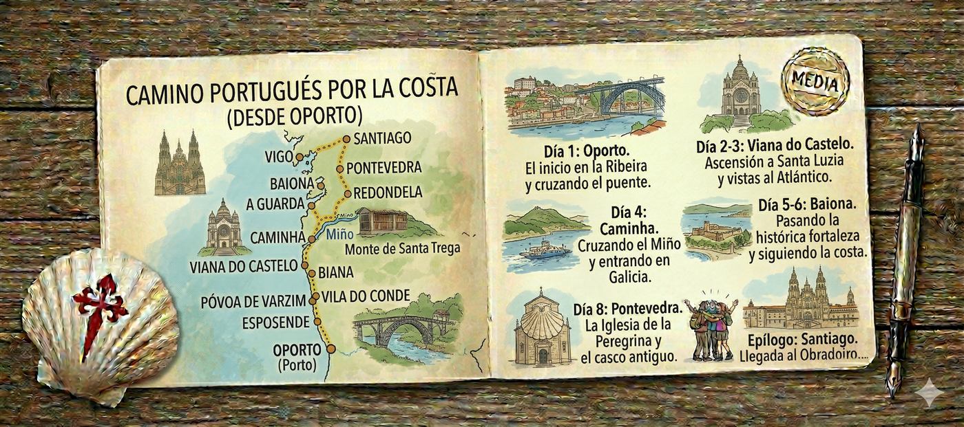
About 265 km from Porto following the Atlantic: wooden boardwalks over the dunes, fishing villages, the ferry across the Miño to A Guarda and the Galician coast of Baiona and Vigo. At Redondela it joins the Central Portuguese route to reach Santiago together.
Work out your Camino
Move the slider to your pace. Suseia then splits the route into stages based on the albergues in each town, and you can adjust them by hand.
Each dot is a day of walking to Santiago.
The route at a glance
Endless beaches and wooden boardwalks in northern Portugal, lighthouses, hillforts and cliffs on the Galician coast, and the estuaries of Vigo and Pontevedra before the climb to Santiago. It is the way of the sea, with more breeze and less heat than inland.
Stage by stage
The usual split from Porto. From Redondela the path is the same as the Central Portuguese route, and those stages link to its guide.
From the Douro to the Miño along beaches, dunes and fishing towns: Matosinhos, Vila do Conde, Esposende, Viana do Castelo and Caminha.
The Miño ferry takes you to A Guarda. Then the monastery of Oia by the sea, Baiona, Vigo and the shared route with the Central from Redondela.
Distances are approximate: they can vary by a kilometre or so depending on the variant you take.
When to go
April to October. In summer the heat is easier than inland thanks to the breeze, although the beaches and coastal albergues are busier.
In winter the Atlantic wind and rain make some stages hard, and the Miño ferry may not run in bad weather or at low tide.
2027 is a Holy Year: from Redondela the two Portuguese routes come together and it will be busy. Book in high season.
The Compostela
To get the Compostela you must walk at least the last 100 km. A Ramallosa, next to Baiona, is about 113 km from Santiago: six stages to the cathedral.
Vigo is already under 100 km, so if you want the Compostela start in Baiona or earlier.
Start with the A Ramallosa – Vigo stage →Common questions
About 265 km from Porto to Santiago. From Lisbon to Porto the route is the same as the Central one.
By boat, from Caminha to A Pasaxe in A Guarda. It runs depending on the tide and the weather; if there is no service, there are taxis and you can cross at Vila Nova de Cerveira.
The Coastal route has sea views and less heat; the Central has more history and more services. They meet at Redondela.

Choose where you start and how many kilometres you want to walk each day. Suseia builds your plan all the way to Santiago, free and without signing up.
 Suseia